Gran Canaria Airport (LPA)
City Orientation and Maps
(Gran Canaria, Spain)
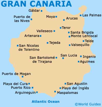
The island of Gran Canaria is one of the famous Canary Islands and is located a long way to the south-west of mainland Spain. Gran Canaria lies to the east of Tenerife and to the west of Fuerteventura, being surrounded by the Atlantic Ocean.
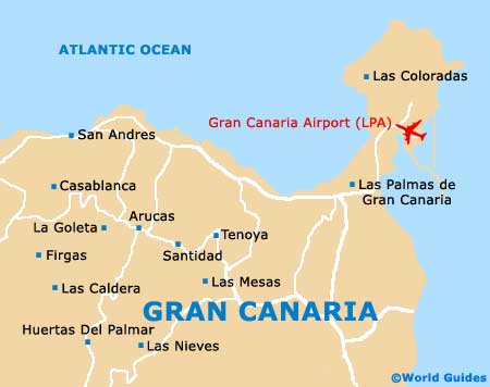
Gran Canaria's most popular towns and resorts are located along the coastline, being particularly clustered towards the south of the island, when you will find many of the best beaches. Popular southerly resorts include San Agustin, the Playa del Inglés and Maspalomas to the east; and Puerto de Mogan, the Playa del Cura, Puerto Rico and Arguineguin to the west. Gran Canaria Airport (LPA) is sited on the eastern side of the island, in the Telde area.
Gran Canaria Airport (LPA) Maps: Important City Districts
Standing on the opposite side of the island, Las Palmas de Gran Canaria can be found along the north-eastern tip and is the capital city. Full of high-rise buildings and modern structures, Las Palmas also contains a wealth of history, with many landmarks dating back to the 15th century. The Puerta de la Luz is located nearby and is a bustling harbour with a number of waterfront attractions. Other notable areas of Las Palmas de Gran Canaria include the Vegueta and Triana district, where the majority of the historic sights reside, and Santa Catalina, a mixture of beach, port and commerce.
Around 12 km / 7 miles the south of Las Palmas, Telde is the second-biggest city on the island of Gran Canaria and is sited to the west of the airport. Telde is perhaps best known for its historic noble houses and 15th-century church, the Basilica de San Juan.
Spain Map

Gran Canaria Maps